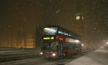
A bus goes past the House of Commons as it crosses Westminister Bridge during a snow fall in London Photograph: Andrew Parsons/Reuters
The heaviest snow for two decades moved into Britain on a freezing easterly wind last night after gathering strength over the North Sea. Falls of up to 10cm (4in) are predicted initially on the south-east coast and inland as far as London before the storms head north.
The Met Office said it was classifying today's expected snowfall as an "extreme weather event".
It was already causing chaos last night as trains were delayed and some airport runways temporarily closed. Gatwick and London City airports were both temporarily shut as their runways were de-iced, although City failed to reopen, as it closes ordinarily at 10pm. A Gatwick spokeswoman said that 23 flights had been cancelled and 18 diverted, although the runway reopened at 10pm.
A number of train services linking London and the south coast were also delayed or cancelled as snow drifted on to the tracks. And all London bus services were withdrawn, according to Transport for London's website.
High ground in Kent and Sussex could see as much as 20cm fall. "Severe disruption to roads and airports is extremely probable during the peak of the Monday afternoon rush hour," said Tom Defty, head of forecasting operations at MetService.
Blizzards and drifts may affect coastal areas and close scores of roads if high winds persist. The northbound M20 in Kent was closed last night between Ashford and Leeds castle after icy roads caused a series of minor collisions. There were no injuries. Forecasters predicted the gathering strength of the cold front would see heavy falls well inland and moving north, with 5cm predicted for Leeds and Bradford in Yorkshire.
Forecasters predict that the freeze will match conditions in the winter of 1991 when blizzards were followed by a prolonged period of temperatures well below freezing. Drifts up to three metres high closed roads and rail lines and shops saw a brief but marked drop in takings as fewer people ventured out.
The current snap is expected to thaw much sooner, with temperatures rising later this week, but further snow is forecast. Overall, the renewed cold spell is certain to seal this winter's dubious distinction of being the coldest for 13 years.
Gale force winds were recorded in several areas offshore as the snow moved towards the long curve of the Yorkshire and Lincolnshire coastline between Bridlington and Skegness.
People across the country were warned to avoid unnecessary journeys, with below-freezing temperatures dropping even further in many areas because of wind chill. The snow follows a relatively mild spell after the three-week freeze in early January which saw lows of -13C (8.6F). The previous coldest winter was in 1995 when -27.2C was recorded at Altnaharra in the northern Highlands.
Bookmakers have cut odds against 2009 being the coldest winter on record from 12-1 to 8-1 but a counter-trend is also seeing betting on a hot summer.
Rupert Adams of William Hill said: "Punters seem to be confidently optimistic about that and we have odds of as low as 6-1 on temperatures topping 100F."
Robert Hutchison of Ladbrokes said bets had started coming in that the Thames would freeze, with odds at 80-1. He said: "We're also seeing plenty of bets on a white Valentine's Day after the disappointment of missing out on snow at Christmas."


No comments:
Post a Comment