Followers

Saturday, August 16, 2008

Experts: Reliance on Russia makes NASA weak

By Lara Farrar

LONDON, England (CNN) -- Experts are growing increasingly concerned that the United States will have to rely entirely upon Russia to take astronauts to and from the international space station for at least half a decade.
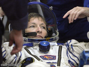
NASA astronaut Peggy Whitson endured a chaotic Soyuz capsule landing in April.

NASA astronaut Peggy Whitson endured a chaotic Soyuz capsule landing in April.

Click to view previous image
1 of 2
Click to view next image

Observers say the situation is all the more worrying as earlier in the week, NASA announced a delay in the launch of its next-generation Orion spacecraft.

NASA's dependency upon the Russian Soyuz space capsules and rockets to carry astronauts to the station is the result of a five-year gap between the scheduled retirement of the shuttle in 2010 and the debut of its replacement in 2015.

The agency had hoped it could narrow this gap by accelerating the initial launch of the craft to 2013 but announced on Monday that because of inadequate funding and technical issues the new Constellation space program would not be ready for testing until September 2014.

While the new date is still within the March 2015 absolute deadline, many experts say NASA's reliance upon Russia to take astronauts into space has placed the agency in an unnecessary position.

"It is a vulnerability," John Logsdon, director of the space policy institute at George Washington University, told CNN.

"Any time you are relying on a single system to do a critical task, you are vulnerable if that system has problems."

"It is our fault for not having a replacement for the shuttle much earlier than Orion will be available. It puts Russia in a very powerful position," Logsdon said.

Russia will be the only country capable of providing human access to space not only for the Americans but also the rest of the world in the near future, said Howard McCurdy, a space expert at American University in Washington.

"It is like a monopoly position where you are at the mercy of that supplier," said McCurdy. "You don't want to be dependent on a single provider no matter who it is."

McCurdy warned that because the United States has positioned itself to be completely dependent on Russia to get humans into space until 2015, it may be harder for the American government to take diplomatic action against the country, especially in light of recent tensions between Russia and Georgia.

"That is a real concern," said McCurdy. "You are much more reluctant to be nasty with somebody who is a sole provider of an essential service.

"We have other international arrangements with them that could be jeopardized by our reliance on them," McCurdy continued. "Everything from their foreign relations with ex-Soviet states to their role in economic summits." Does NASA's dependence on Russia bode badly for U.S. space program?

For its part, NASA says it remains confident that diplomatic affairs between the two countries will not adversely impact the space agency's relationship with Russia.

"While it is possible that government to government issues could potentially have an impact on other aspects of a relationship between nations including cooperative space exploration activities, NASA has no reason to believe that it will be unable to rely upon Roscosmos-provided Soyuz vehicles for future ISS activities," spokesman Michael Curie wrote in an email statement to CNN.

The threat of a breakdown in diplomatic relations is not the only one hanging over NASA's space program.

Legislation passed in 2000 (now called the Iran, North Korea and Syria Nonproliferation Act) could soon bring an abrupt halt to NASA's partnership with the Russian Space Federation, Democratic Senator Bill Nelson of Florida told CNN.

The law bans the United States from buying space technology from Russia unless the president determines Russia is taking steps to prevent the proliferation of nuclear and missile technology to Iran.

Congress waived the ban in 2005, allowing NASA to enter into a $719 million contract with the Russians for use of the Soyuz through 2011.

NASA says it is currently renegotiating a new long-term contract for use of the Soyuz but, according to Nelson, the success of that contract could depend on whether or not lawmakers decide to approve the waiver again.

Election-year politics combined with increasing concerns about Iran and the ongoing crisis in Georgia all but guarantee that lawmakers will not vote for the exemption, said Nelson.

That means NASA could lose access to the $100 billion space station unless it continues to fly the shuttle or strikes some sort of deal with another space agency willing to put forward money for additional Soyuz seats, the Senator explained to CNN.

"It is a lose-lose situation," said Nelson.

"If our relationship with Russia is strained who knows if Russia will give us rides in the future?" Nelson continued. "Or if they give us rides will they charge such an exorbitant price that it becomes blackmail?"

Questions about the safety and reliability of the Soyuz have also been raised in recent months after two consecutive troublesome landings by space capsules, including one in April with American astronaut Peggy Whitson on board.

NASA has been working with Russian engineers to try to determine the cause of the dangerous descents but has so far failed come up with any concrete answers.

But NASA officials say the space agency still believes the Soyuz is a reliable transport system for its astronauts.

"We do not have concerns," NASA spokesman Rob Navias told CNN. "The Soyuz, which has been flying for decades now, is extremely reliable and is extremely capable."

"We have been partnering with the Russians for decades now for space flights."

The Russian Federal Space Agency, Roscosmos, could not be reached for comment on the matter.

Original here

Phoenix Microscope Takes First Image Of Martian Dust Particle

NASA's Phoenix Mars Lander has taken the first-ever image of a single particle of Mars' ubiquitous dust, using its atomic force microscope.

The particle -- shown at higher magnification than anything ever seen from another world -- is a rounded particle about one micrometer, or one millionth of a meter, across. It is a speck of the dust that cloaks Mars. Such dust particles color the Martian sky pink, feed storms that regularly envelop the planet and produce Mars' distinctive red soil.

"This is the first picture of a clay-sized particle on Mars, and the size agrees with predictions from the colors seen in sunsets on the Red Planet," said Phoenix co-investigator Urs Staufer of the University of Neuchatel, Switzerland, who leads a Swiss consortium that made the microscope.

"Taking this image required the highest resolution microscope operated off Earth and a specially designed substrate to hold the Martian dust," said Tom Pike, Phoenix science team member from Imperial College London. "We always knew it was going to be technically very challenging to image particles this small."

It took a very long time, roughly a dozen years, to develop the device that is operating in a polar region on a planet now about 350 million kilometers or 220 million miles away.

The atomic force microscope maps the shape of particles in three dimensions by scanning them with a sharp tip at the end of a spring. During the scan, invisibly fine particles are held by a series of pits etched into a substrate microfabricated from a silicon wafer. Pike's group at Imperial College produced these silicon microdiscs.

The atomic force microscope can detail the shapes of particles as small as about 100 nanometers, about one one-thousandth the width of a human hair. That is about 100 times greater magnification than seen with Phoenix's optical microscope, which made its first images of Martian soil about two months ago. Until now, Phoenix's optical microscope held the record for producing the most highly magnified images to come from another planet.

"I'm delighted that this microscope is producing images that will help us understand Mars at the highest detail ever," Staufer said. "This is proof of the microscope's potential. We are now ready to start doing scientific experiments that will add a new dimension to measurements being made by other Phoenix lander instruments."

"After this first success, we're now working on building up a portrait gallery of the dust on Mars," Pike added.

Mars' ultra-fine dust is the medium that actively links gases in the Martian atmosphere to processes in Martian soil, so it is critically important to understanding Mars' environment, the researchers said.

The particle seen in the atomic force microscope image was part of a sample scooped by the robotic arm from the "Snow White" trench and delivered to Phoenix's microscope station in early July. The microscope station includes the optical microscope, the atomic force microscope and the sample delivery wheel. It is part of a suite of tools called Phoenix's Microscopy, Electrochemistry and Conductivity Analyzer.

Original here

3 Controversial Maps

Buzz up!
Rob Lammle
by Rob Lammle

1. The One With Only 38 States

1973_38-States-500.jpg

[Click on the map for a larger view.]

If George Etzel Pearcy had his way, Lynyrd Skynyrd’s famous song would have been called “Sweet Home Talladego.” In 1973, the California State University geography professor suggested that the U.S. should redraw its antiquated state boundaries and narrow the overall number of states to a mere thirty-eight.

Pearcy’s proposed state lines were drawn in less-populated areas, isolating large cities and reducing their number within each state. He argued that if there were fewer cities vying for a state’s tax dollars, more money would be available for projects that would benefit all citizens.

Because the current states were being chopped up beyond recognition, part of his plan included renaming the new states by referencing natural geologic features or the region’s cultural history.

While he did have a rather staunch support network—economists, geographers, and even a few politicians argued that Pearcy’s plan might be crazy enough to work—the proposal was defeated in Washington, D.C. Imagine all the work that would have to be done to enact Pearcy’s plan: re-surveying the land, setting up new voter districts, new taxation infrastructure—basically starting the whole country over. It’s easy to see why the government balked.

The map above was published in 1973. Oddly, it doesn’t show any city locations to help illustrate Pearcy’s argument. At this point, I should tell you that I make maps for a living. So I did my best to replicate Pearcy’s map using population data from the 2000 census to show current high population cities and where they would fall within the new states. Here’s what I came up with:

2008_38-States.jpg

[Click on the map for a larger view.]

As you can see, many of the new states contain a small number of major metropolitan areas, and the problem of dual-state cities has been solved. While Pearcy’s proposal might have been a logistical nightmare to make a reality, that doesn’t necessarily mean it was a bad idea.

2. The One Where Greenland & Africa are the Same Size

Mercator-World-Map.jpg

In 1973, Arno Peters, a German filmmaker and journalist, called a press conference to denounce the widely accepted map of the world known as the “Mercator Map” (above). Peters’ position was that the Mercator Projection—a cylindrical projection first developed in 1569 by Flemish cartographer Gerardus Mercator—was not only inaccurate, but downright racist. Peters pointed out that the Mercator map has a distortion in the northern hemisphere, making North American and Eurasian countries appear much larger than they actually are. For example, Greenland and Africa are shown as roughly the same size, although in reality Africa is about fourteen times larger. In contrast, the regions along the equator—Africa, India, and South America, to name a few—appear smaller, especially when seen next to the distorted northern half of the map. It was Peters’ belief that this error led many in the developed world to ignore the struggles of the larger, poorer nations near the equator.

Of course Peters had a suggestion on how to fix this problem—his own map. The Peters Projection map, which claimed to show the world in a more accurate, equal-area fashion.

Gall-Peters-Projection.jpg

Because Peters’ map showed the size of developing nations more accurately, charitable organizations that worked in those regions quickly gave him their endorsement. Eventually his map became so well received that some were calling for an all-out ban on the Mercator map, believing it to be an outmoded symbol of colonialism.

The thing is, cartographers agreed that the Mercator map was outdated, inaccurate, and wasn’t the best way to represent the world’s landmasses. They’d been calling for the use of a new projection since the 1940s.

One of the reasons experts wanted to move away from the Mercator was because of the distortion. However, they also understood that it was distorted for good reason. The Mercator map was intended as a navigational tool for European mariners, who could draw a straight line from Point A to Point B and find their bearings with little trouble. Because it was made for European navigators, it was actually helpful to show Europe larger than it really was. It wasn’t a political statement, but a decision made purely for ease-of-use.

However, the biggest insult to cartographers was the Peters projection itself. Peters claimed to have created the projection, when in fact, it was essentially the same thing as devised in 1855 by a cartographer named James Gall. Many have recognized this similarity and now you’ll often see Peters’ map called “The Gall-Peters Projection.”

Today, the controversy is mostly dead. Both projections are seen as flawed and have fallen into disuse as more accurate maps have been developed. In classrooms now, you’re more likely to see the Robinson Projection or the Winkel Tripel Projection. The Gall-Peters map is still favored by some organizations, though many map publishers don’t even produce it anymore. And despite the controversy, the Mercator projection is still one of the most widely used navigational tools in the world—it’s the primary projection for Google Maps.

3. The One that Claims the Chinese Got Here First

zheng-he.jpg

[Click on the map for a larger view.]

It seems everyone wants to ruin Christopher Columbus’ biggest claim to fame. This time it’s a Chinese map that is threatening to rewrite history.

Purchased from a Shanghai dealer in 2001 by Liu Gang for a mere $500, the map shows the world—including a well-developed picture of North and South America. While text on the map indicates it was drawn in 1763, it claims to be a copy of another map drawn in 1418. The original map was cited as belonging to the great Chinese explorer, Zheng He, whose known travels include India and eastern Africa. However, thanks to numerous errors and anachronisms, the map’s authenticity has been called into question.

For example, California is shown as an island, which is a famous mistake made by European maps of the 17th Century. Furthermore, the detailed representation of river systems would be difficult to attain by such large ships as those used by Zheng He, whose fleets sometimes carried up to 28,000 men. Finally, the Chinese did not have an understanding of how to create a map projection at that time, a skill necessary to translate a 3-D globe to a 2-D map. In short, they didn’t even know how to make this map when it was supposed to have been drawn.

The annotations on the map also seem to be largely erroneous. A perfect example is a note stating of Eastern Europe: “The people here all worship God (shang-di) and their religion is called ‘Jing.’” However, according to noted professor and map critic, Dr. Geoff Wade, the term “shang-di” for the Christian God was not introduced until the late 16th Century. Perhaps most damaging are the many references to the “Great Qing Ocean” regarding the waters off China. Unfortunately, the Qing Dynasty began in 1644—more than 200 years after the original map was supposed to have been made.

Based upon this evidence, it seems likely that the Chinese map of the New World is the product of a 1763 cartographer using the terminology of his time, combined with data from European maps. Therefore, while Zheng He can definitely claim to be a great explorer, it is doubtful he ever made it to America.